B&G Zeus² MFD’s and Glass Helm, Simrad NSS/NSO Evo2 Multifunction navigators
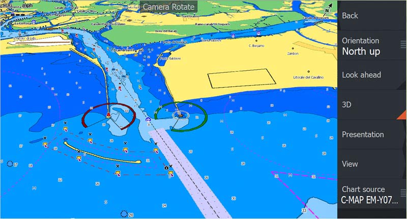
Global electronics chart provider C-MAP by Jeppesen has announced the launch of its new software for B&G’s Zeus² Multifunction Displays (MFDs) and Zeus² Glass Helm navigation systems, together with the Simrad Evo2 MFDs. The software provides compatibility with the latest C-MAP MAX-N+ 2015 cartography which delivers a host of new features and content for electronic navigation, enhancing the boat owner’s enjoyment afloat and improving navigation and safety on the water.
C-MAP MAX-N+ 2015 cartography brings proven C-MAP 4D chart content in addition to European inland lakes, waterways and rivers. The Easy Routing feature can automatically plot the shortest, safest course based on the specific draft, beam and height of the owner’s vessel. The system allows for quick creation of routes, of up to 100 nautical miles, which can then be saved for future passages. With C-MAP MAX-N+ 2015 users can now manage and control the depth colours either for safety purposes using the Safety Shading feature and/or fishing purposes with the Depth Shading option.
Simrad and B&G users can now also benefit from Dynamic Raster Charts which have the look of traditional paper charts yet provide the ability to “open up” and view information on a variety of important chart objects such as NavAids, reefs, charted obstacles and more. Another key feature of the MAX-N+ 2015 cartography is Dynamic Tides & Currents. This feature provides surface current information in both graphical form and coloured icons to display the strength and direction of the tide which is invaluable to both yacht and motorboat owners for safe and fast passage making.
Jeppesen’s world wide database of Marina and Port plans provide high resolution satellite imagery for coastal areas and detailed aerial photographs of harbour entrances, channels and marinas. This feature of MAX-N+ 2015 ensures that owners can enter new harbours safely and enjoy its facilities with local knowledge at their fingertips.
Yacht racers with the new B&G software can unlock a range of new functions that work in concert with Jeppesen’s latest cartography, including RacePanel, scaled Start Line View, Wind Phase and H5000 Start Line Control with many other features designed to enhance the racing experience and accuracy. Fishing vessels with compatible Simrad MFD’s will benefit from Jeppesen’s worldwide library of high-resolution, bathymetric bottom contour data which helps to effectively target underwater pinnacles, ledges and other structures known to concentrate certain fish types.
C-MAP MAX-N+ 2015 Local or Wide charts can be purchased through Jeppesen dealers throughout Europe, Middle East and Africa on pre-programmed micro SD cards, or online through the Navico GoFree website at www.gofreemarine.com.
To benefit from the new C-MAP MAX-N+ 2015 owners of Simrad NSO Evo2 MFD’s must first update to software Version 4.0 while fishermen and boaters who wish to run the cartography on Simrad NSS Evo2 MFD’s should obtain a free online update to software version 3.0. Users of the B&G Zeus² navigation systems should update to B&G’s RTM 3.0 software.
C-MAP MAX-N+ 2015 can be seen on the Jeppesen stand number X9 in hall B at the Genoa Boat Show from September 30th – 5th October.

